Saturday, May 13, 2023, in the Netherlands on day 3 (day 12 of my trip).
Day 12
I had discussed with my friend that I wanted to go somewhere new and do something significant, likely distant from Rotterdam. I had long wanted to visit one of the Dutch islands that curves the country’s border in the North Sea from the area north of Amsterdam to Germany. The largest and easiest to visit one is Texel Island.
We left the house at around 8 AM to cycle to Rotterdam Centraal and ride the Intercity Direct train, with our bicycles, to Amsterdam Centraal station, where we changed to an Intercity train to Den Helder, a city at the tip of the Dutch mainland north of Amsterdam. The train arrived in Den Helder at 11 AM, where we picked up some snacks and cold sandwiches at Albert Heijn (the largest supermarket chain in the country), and rode over to the TESO ferry’s terminal.
Like many other ferries in the world, tickets are purchased only in one direction because of the assumption that you’re going to use the ferry to return (and Texel Island has no road crossings so a boat is the main way on and off). Another neat thing about this ferry is that pedestrians and bicycles are able to disembark and board simultaneously because outgoing bicycles are parked only on the right side of the boat and there is a one-way on and one-way off system for pedestrians and bicycles.
On the ferry
I wasn’t prepared to board this ferry. After we parked our bicycles in the designated area and went upstairs to the cabin I was floored at the cruise ship-like appearance. There was a self-service café, enormous bathrooms, a children’s play area, artificial trees, and a variety of seating options – single seats, seats with tables, couches to look out the side and couches to look out the front.
Ferry bike parkingArtificial tree inside the TESO ferry between Den Helder and Texel
After inspecting the map of cycle routes on the island my friend and I decided to ride around the whole island clockwise. (An advantage of riding clockwise that day was to have a tailwind in the second half of the journey, when we would be tired.)
On the island…
…we saw everything.
sheep
dunes
polders
Scottish Highlander cattle
forests
farms
tons and tons of e-bikes – I think that acoustic bikes were in the minority!
a lighthouse
beach cabanas
tulips
sea protection walls
passed through the towns of De Koog and De Cocksdorp
According to the tracking I did on Strava we rode 37.6 miles.
Heading home
On the return ferry my friend consulted the NS Travel Planner app to figure out the best itinerary of trains back to Rotterdam, as well as to figure out the time between the ferry’s arrival and the next train’s departure. It would be close, he said. We would need to exceed the Google Maps estimate of cycling time between the terminal and the station. And, he said, it’s likely that other people with bikes on this ferry also want to take the train and Dutch trains have a very small amount of space for bikes.
We cycled fast, and we made it onto the train about two minutes before departure. At Zaandam we changed to a Sprinter to Hoofddorp via Amsterdam Schiphol airport and at the airport station we changed to an (older) Intercity Direct train to Rotterdam. (The Intercity Direct train we took from Rotterdam in the morning was the new ICNG – next generation – set, and these trains have space for more bikes.)
An ICNG train at Rotterdam CentraalBays of 4 seats have a small tableCouches in the new ICNG trainMood lightingLuggage rack in the ICNG, in addition to the standard overhead racks. This train serves the airport and the new design should better serve airport passengers, and improve the comfort of everyone else not going to the airport who must encounter all of the luggage everywhere.
Update: On December 5, 2022, Metra modified the UP-West schedule so that every mid-day train stops at the Kedzie station.
Of the many things Metra does to discourage ridership, here’s a new one to me: You go up to the platform towards your destination and there’s a sign that says “your train might actually stop at the other platform, which is entered from the other side of the street”.
I was with two friends and we were planning to board a Metra UP-West train to Geneva, Illinois, to start a bike ride on the Fox River Trail.
What the sign actually says, as you can see in the photo, is “Notice! Some trains from Chicago board from opposite platform”, but I think my interpretation is accurate.
The sign at the station increases stress. It would be slightly more helpful if there was another sign that said which trains this situation would apply to.
We brought our bikes up to the platform that was labeled “trains from Chicago”, which Metra has labeled “Platform 2”. Union Pacific, which runs their freight trains and operates Metra’s trains, is a left-running railroad in Chicago, meaning trains run on the left track in the direction of travel.
A minute after we settled in to wait 10 minutes for the train, we noticed the sign. A freight train started down this track, and we’re wondering, “is this freight train the clearest indication that we should head now to the other platform?”
We even tried to deduce which track the outbound train would run on by watching signals (one will eventually turn green).
The container freight train passed our platform, preventing a Metra train from arriving there. But maybe the freight train would clear the tracks soon enough for the outbound Metra train to stop here?
When it looked like the freight train wasn’t gonna clear the track in time, we moved to the other platform. It’s good we did. About 1 or 2 minutes before the train arrived, an announcement confirmed our choice of platforms. Phew!
What made this maneuver of ours between platforms complicated was that we had bikes and it takes an extra moment to carry them down and back up stairs.
While the Metra approached and started slowing down, there was just the slightest fear it wasn’t actually going to stop. The train had more coaches than necessary for the demand and only the last car opened. So you watch like 7 coaches pass by.
This being the Kedzie station on UP-West, we were probably three of 10 riders here this whole week. In the current schedule, only 41 percent of the weekday trains stop here.
The announcement of the boarding platform was hard to hear over the freight train noise, the platform identification sign for “Platform 1” – the middle platform – took a moment to see and verify. But, and here’s the clincher to this part of the story, the announcement didn’t come with enough slack for us to have “run” over to the correct platform – with our bikes – and not feel stressed about what should be a seamless ride-up-to-the-platform-and-board start to the trip.
Photo from “Platform 1” (a center platform) with our arriving Metra train on the left and the freight train that ended up stopping in front of the original platform we ascended.
We took the last outbound train of the morning that stops at Kedzie to Geneva. Then we biked south on the beautiful Fox River Trail to Aurora. We missed the train and didn’t want to wait 2 hours (😬) for the next one so we biked northeast to Wheaton along the Illinois Prairie Path’s Aurora Branch and made it on that inbound train just in time to go home.
A map of our journey shows the 25 mile bike route from Geneva to Aurora via the Fox River Trail (cycling mostly on the west bank), and from Aurora to Wheaton via the Illinois Prairie Path’s Aurora Branch. Interurban trains used to run along both trails.
We saw a new piece of “regional” infrastructure on our trip, a new pedestrian and bike bridge over the Fox River in Aurora, Illinois. The verdict on their brand new pedestrian & bike bridge is…it’s very cool. I wish it had greenery, though.
The brand new Riveredge Park Pedestrian Bridge was opened on June 11, 2021.
The bridge is characterized by a large, central, vertical concrete beam that provides the structural spans. At the ends of the bridge, the beam separates the walking and biking paths, but at the center the decks rise up while the beam appears to drop down and there’s an open and combined deck at the center. The deck is also widened at the center so that there’s some gathering space outside of the paths of travel.
The deck rises up and the center structural beam appears to drop down as you reach the center of the span. The dropped beam creates some bench seating. The center seam is for illuminating the space above the bridge. Behind the photographer is an opening between the center beam to create a gathering space and a crossover point.
Visiting the Fox River Trolley Museum is a fun day trip for anyone who likes Chicago train history or trolleys and streetcars generally. The FRTM is free to browse, and rides cost $5 each or pay $8 for unlimited rides (adult prices).
Decades ago, it was possible to ride this Chicago Aurora & Elgin train all the way Batavia, Illinois, from Chicago. The CA&E’s former right of way is now the Illinois Prairie Path, the first rails-to-trails project in the United States.
The museum is not accessible to people with disabilities. It’s open Sundays from May to October and some holidays (check their calendar). The museum has two portable restrooms, but I recommend using the permanent and spacious ones in County Park.
Trip option 1, the short and direct option: Take Metra’s MD-West line to National Street and bike 15 minutes south along the Fox River Trail. The trail passes County Park, where there’s a playground, restrooms, and bike parking. Lock your bike here and walk on the gravel path from the park to the outdoor museum.
Trip option 2a, the really convenient option: Have a friend who loves planning multi-modal bike trips dig into the Metra schedules and send calendar invitations to everyone in the group so there’s great expectations as to when and where the trip starts and ends. Thank you, D.S.!
Trip option 2b, the longer one that incorporates more cycling: Take Metra’s BNSF line to Aurora Transportation Center (ATC). The BNSF line has Metra’s new bike cars on specific runs (check the schedules). This is important because it means you can bike with a larger group of people than before since your group’s size is less subject to capacity constraints for bikes on standard Metra trains – without bike cars – and unpredictable directions from Metra conductors. Additionally, on standard Metra trains, the posted bike capacity may be inaccurate if the conductors have not opened all of the coaches.
This is the bike car on Metra’s BNSF line, at the Aurora Transportation Center.
After disembarking at the ATC, ride to the north side of the center towards the river and use the signalized intersection to cross the high-speed road to the Fox River Trail. From here on out you’ll be following the FRT northward via its off-street and on-street sections. The trail is mostly off-street, so that’s fun, and it’s nice to have so much shade.
You can basically just bike north and follow the FRT signs but you may want to review a trail map ahead of time because it’s often possible to bike on either side of the Fox River and there are advantages to riding on one side over the other in some segments. For example, from downtown Batavia north to Fabyan Villa, I prefer the west side. At Fabyan Villa you’ll have to switch to the east side.
From Aurora, look for FRT direction signs that say “Batavia”, and then “Geneva”, and then “St. Charles”, and finally “South Elgin”. I believe the only option for cycling through downtown St. Charles is on-street, and there are some hills on its FRT street sections so be prepared or look for an alternative route.
This is as good a point as any to mention that you could shorten the bike trip by taking Metra’s UP-West line to Geneva, which is north of Aurora, and heading on downhill streets to the riverfront and crossing the pedestrian bridge underneath the Metra tracks to join the Fox River Trail on the east side to head north.
My two friends and I ate at Flagship on the Fox, an American restaurant and pub with seating indoors, on a covered patio, and outdoors. The Flagship Burger, with onion rings, avocado, bacon, and white cheddar cheese was delicious. Next door is Pollyanna Brewing Company, but which doesn’t sell food.
A lot of the FRT follows the old Aurora, Elgin and Fox River electric railway line! Can you believe that there used to be interurban trains running up and down the Fox River connecting the towns there (which I mentioned above)?
The Aurora, Elgin & Fox River Electric was an interurban offering both freight and passenger service between Yorkville and Carpenter, Illinois. Operations began as early as 1895 and closely followed the Fox River for its entire route. It underwent several mergers and names over its lifetime before eventually becoming 40 miles in length and operating two streetcar services in Aurora and Elgin.
As with most interurbans, the AE&FR was overtaken by buses and the automobile, and passenger service was discontinued in 1935. Freight service continued along portions of the route up until 1972.
The AE&FR ran on the Fox River’s west bank from Aurora to St. Charles, where it switched to the east bank. On approach to South Elgin, however, and due to a big bend in the Fox River, it kept going straight and found itself on the west bank again.
A bend in the Fox River moves the AE&FR interurban line from the east bank to the west bank again. The former AE&FR bridge crossing the bend in the Fox River is now part of the Fox River Trail. Photo: Eric Allix Rogers
A minute or two after crossing the bend in the Fox River on the former interurban’s bridge, you’ll encounter the southern end of the Fox River Trolley Museum’s demonstration track. Less than 10 minutes later and you’ll be arriving at County Park where I recommend parking your bike.
What’s the timing on this? I don’t know. My friends and I took our time cycling and stopping for photos and eating. The relaxed riding nearly prevented us from being able to ride a trolley. The museum runs a trolley once an hour every hour, and we arrived a few minutes after the most recent trolley left the station. We needed to be in Elgin to ride Metra’s MD-West line back to Chicago at 15:55, and the next full ride would take so long that we would miss that train, and since it’s Sunday, it’s safe to assume that the next Metra train runs two hours later.
The volunteer staff at the museum were sympathetic to our case and created a special charter for just the three of us! The two operators and an apprentice took us on a shortened journey down the line, from Castlemuir (the home station) to a switching yard of sorts halfway down the line. The yard is where trains could be rerouted to a track that joined up with former Illinois Central tracks going east-west.
Our motley crew. Eric captioned this, “NBD just a private excursion along the Fox River in an old North Shore Line car!” Photo taken by one of the qualified train operators.
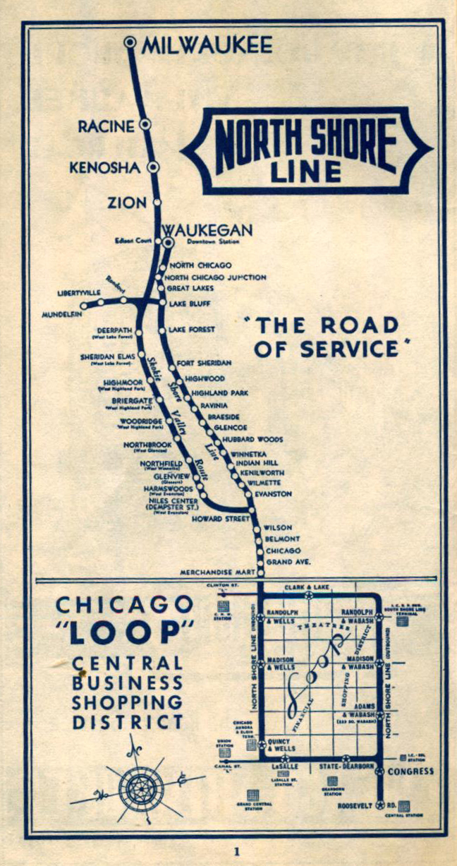
We rode the former North Shore Line car 715. This car used to run between Chicago and several cities along the North Shore, including Evanston and Willmette (where the Chicago Transit Authority’s Purple Line runs now), Skokie (where the CTA’s Yellow Line runs), and further north to Milwaukee. Check out the North Shore Line’s route map on the Northwestern University Transportation Library’s website.
You would have also seen car 715 running around the Chicago elevated loop, and making stops at the existing Belmont and Wilson elevated stations (although both of those have been replaced and tracks re-aligned for slightly faster service).
Once you’re done enjoying the historic trains at the FRTM, get back on the Metra and go home. Check out Elgin’s riverfront if you have to wait, and there are restaurants in downtown Elgin.
I’m adding Chicago-area campgrounds to the Chicago Bike Guide to entice new users and to espouse the enjoyment of medium-distance bike camping (which I’ve now done officially once, earlier this year).
<The Chicago Bike Guide is available for Android and iOS.>
I’m taking a systematic approach to finding all the publicly-owned campgrounds in the area by looking at primary sources.
First, though, I’ve used Overpass Turbo to create a list of all existing campgrounds in OpenStreetMap. You can see a gist of these places.
Camp sites at Greene Valley forest preserve I mapped.
The next method is to find out which campgrounds are operated by the county forest preserves, which are usually well-documented on their respective websites. Then I will look at state parks in Illinois, Indiana, and Wisconsin, operated by states’ respective Departments of Natural Resources (DNR). Next I will look at national parks and finally commercial campgrounds.
The app will display campground information such as alcohol rules, if cabins or lodging is available, and how you can get there (which trails or train lines).
I’ve so far mapped the campgrounds in two ways, as nodes and as areas. At the Greene Valley forest preserve in DuPage County, for example, I’ve mapped the 11 individual camp sites (see map), but at Blackwell forest preserve in the same county, I’ve mapped the area as the camp site (see map).
Blackwell has over 50 sites in a discrete area and it’s more efficient to map them as a single node, while Greene Valley had far fewer sites but scattered over a couple areas.
BE IT RESOLVED that you should not leave your bicycle parked at the Clybourn Metra station overnight as it is a terrible place to leave a bicycle parked. Why? No one is around most of the time to socially secure your bicycle.
This is a great place to get your bike stolen. In the dark. Overnight. With no one around to see it happen.


