ChicagoCrashes dot org was, for many years, the only source for people to get information about traffic crashes in Chicago. I started it in 2011.
A screenshot of Chicago Crash Browser v0.2 showing what the website looked like on December 30, 2011.
It was updated annually with data from two years ago, because of how the Illinois Department of Transportation processed the reports from all over the state. I shut it down because it had outdated code, I was maintaining it in my free time, and I didn’t want to update the code or spend all the time every year integrating the new data.
In 2015, the Chicago Police Department started testing an electronic crash reporting system in some districts that meant police officers could write reports and they would immediately show up in a public database (in the city’s data portal). The CPD expanded this to all districts in September 2017. (A big caveat to using the new dataset is that it has citywide data for only four and a half years.)
Since then, whenever someone asked me for crash data (mostly from John to illustrate Streetsblog Chicago articles), I would head to the data portal and grab data from just the block or intersection where someone had recently been injured or killed. I would load the traffic crash data into QGIS and visualize it. I found this also to be painstaking.
Now, with renewed attention on the common and unfixed causes of KSIs (“industry” term for killed or seriously injured) that we’re seeing repeatedly across Chicago – read about the contributing cause of Gerardo Marciales’s death – I decided to relaunch a version of Chicago Crash Browser.
The new version doesn’t have a name, because it’s part of the “Transportation Snapshot” in Chicago Cityscape, the real estate information platform I operate. It’s also behind a paywall, because that’s how Chicago Cityscape is built.
I wanted to make things a lot easier for myself this round and it comes with a lot of benefits:
Explore all crash reports in a given area, whether that’s one you draw yourself or predefined in the Cityscape database.
Quickly filter by crash type (bicyclist, pedestrian, etc.) and injury severity.
Download the data for further analysis.
What the crash data looks like within Chicago Cityscape.
How to access the Chicago Crash Browser
The crash data requires a Cityscape membership. I created a new tier of membership that cannot be signed up – I must grant it to you. It will give you access only to Transportation Snapshots.
Mention or DM me on Twitter, @stevevance, saying you’d like access to the crash data. Tell me what your email you used to create an account on Chicago Cityscape.
I’ll modify your membership to give you access to the “transportation tier” and tell you to sign out and sign back in to activate it.
Once you’re in, this video shows you how to draw a “Personal Place” and explore the traffic crash data there. Text instructions are below.
From the Chicago Cityscape homepage, click on “Maps” in the menu bar and then click “Draw your own map”.
On the “Personal Place” page that appears with a large map, decide which shape you’d like to draw: a circle with a radius that you specify (good for intersections), a square or rectangle (good for street blocks), or an arbitrary polygon (good for winding streets in parks). Click the shape and draw it according to the onscreen instructions. For intersections I recommend making the circle 150 feet for small intersections and 200 feet for long intersections; this is because intersections have an effect on driving beyond the box.
Once you’ve completed drawing the shape, a popup window appears with the button to “view & save this Personal Place”. Click that button and a new browser tab will open with something called a “Place Snapshot”.
In the Place Snapshot enter a name for your Personal Place and click the “Save” button.
Scroll down and, under the “Additional Snapshots” heading, click the link for “Transportation & Jobs Snapshot”; a new browser tab will open.
In Transportation Snapshot, scroll down and look for “Traffic crashes”. You’ve made it to the new Chicago Crash Browser.
This blog post was inspired by Steven Lucy’s comments on Twitter about three different “regional rail” networks.
New York Governor Kathy Hochul announced in her State of the State speech the other day that the Metropolitan Transportation Authority (MTA), a state authority that operates New York City’s transit, would do a feasibility study for the “The Triboro” (or “Interborough Express”).
The line would use existing freight railroad rights of way to connect Queens and Brooklyn (ironically there isn’t a third borough connection).
Screenshot of a tweet from @RegionalPlan on January 5, 2022. Text of the tweet: “🚨 TRIBORO IS MOVING FORWARD 🚨 @GovKathyHochul just announced @MTA will launch an environmental impact statement for Interborough Express, an above-ground rail line using existing tracks through Brooklyn and Queens, and two-thirds of RPA’s Triboro proposal #StateOfTheStateNY
Transit Twitter has been abuzz, as reusing infrastructure is a really good idea!
John Surico, a professor in New York City, tweeted, “Wonder if NYC is about to have its London Overground moment. An overlooked transit project using freight lines, ended up being way more popular than expected. Since led to new routes, changed where Londoners saw themselves living, and connected otherwise disconnected locales.”
Steven Lucy, a business owner in Chicago, said in response, “Everyone says ‘Chicago RER’ or ‘Chicago S-Bahn’ but I think Chicago is ripe for a London-style Chicago Overground.”
I think all three – RER, S-Bahn, and London Overground – can be grouped as “regional rail”, which constitutes passenger trains running between center cities and their suburbs, stopping at the major stations and a few key stations in the cities, at frequencies higher than commuter and intercity rail and lower than rapid transit.
Regional rail is not quite a walk-up-and-board service, but it’s better than having the hourly or every other hour off-peak service that most United States cities with passenger trains endure.
What are they?
Someone asked Lucy, “What’s the difference between those three?”
Lucy: “My view: they all kind of operate similar service but have different histories.”
I’ll summarize those, and show some of my photos since I’ve ridden and experienced all three types of regional rail.
S-Bahn
Lucy: “Most S-Bahn systems share tracks and stations with long-distance trains (Berlin huge exception) and mainly serve one corridor in city center with branches to burbs.”
Most S-Bahn trains in Germany have the same livery: Blocks of red with white around the doors. The Munich S-Bahn train is shown above. The Berlin S-Bahn, pictured below, is the oddity.
The “S-Bahn” branding, in particular, is used only in German-speaking countries, while in Denmark you’ll find the S-tog. The Wikipedia article for S-train reports a few other networks with similar branding.
S-Bahn trains typically use the same fare structure as the metros (rapid transit) they intersect with. And, in Germany, most S-Bahn trains look the same! Berlin is a major exception, and there are also some smaller networks with unique liveries. German regional transit is owned by cross-state cooperative transit agencies called “zweckverband” (a singular word there) who can operate lines themselves or contract them to other operators, and often S-Bahn services are contracted to DB, the federally-owned railway corporation.
RER
Lucy: “RER was built from scratch post-war, mostly underground in city, to relieve both metro lines and traditional commuter rail.”
When used without qualifiers, RER means “Réseau Express Régional” in French, for Regional Express Network, and the term refers to the hybrid system used in Île-de-France, the region that includes Paris and its suburbs. Many of the lines are interlined, meaning they share routes and stop at some of the same stations. That means that some stations will have high-frequency service and appear to have a “walk up and go” function, but not all trains stopping there are going to the same place.
RER trains are double decker. This model also has very wide doors with level boarding. Sydney’s regional rail trains (SydneyTrains) also have very wide doors and level boarding, which facilities expeditious boarding and deboarding.
The acronym works great in English, though –Regional Express Rail – and it’s being used in Toronto to denote a project to increase frequencies on the GO Transit commuter rail lines.
To call something that’s not in Paris “an RER” would mean that a transit authority is increasing the frequencies and service hours (later runs) of a commuter line and adjusting the fare structure to make it usable for more people.
The goal is to build a transit system that supports non-work trips at any time of the day for everyone; rather than weekday rush hour commuters that many regional trains in the United States (cough Metra cough) serve.
It’s debatable whether the Long Island Railroad (LIRR), Metro North Railroad (MNR), and New Jersey Transit (NJT) in the New York City metropolitan area are a type of “RER”. There are some periods in their schedules, outside of peak periods, when there is better than hourly service, but the two systems do not have fare integration with buses, PATH subways, or NYC Subway, adding a barrier to people using the complete network.
London Overground
Lucy: “Overground took over some underused / disused lines and is kind of a lower-capacity mesh to the complement the Underground, mainly non-radial trips.”
On the Transport for London map, all Overground lines share the same hue of orange, and are identified by their geographic names. S-Bahn lines are typically called “Sx” where “x” is a number, and the five RER lines are letters A through E.
Hoxton station on the East London line.
I think it’s neat that the London Overground runs on original embankments between buildings in the city, making its presence very visible, much like the stations on Chicago’s four-track North Side Main Line (all of the Red, Brown, and Purple Line stations north of North Avenue).
One thing that several people noted in the various branches of conversations on Twitter were the effect on land use and development after the London Overground lines opened. I don’t know the details, but some said it accelerated gentrification.
A London Overground train arrives into Hoxton station.
In Chicago, I don’t think converting Metra to an RER system would accelerate gentrification across the system because the current characteristics that inhibit or mitigate gentrification in many of Chicago’s neighborhoods (one of that characteristics is Chicago’s segregation and aldermanic privilege situation, which is better described by the Chicago Area Fair Housing Alliance).
The situation would be a little different if Metra added new stations or restored historic stations, as stations change market and neighborhood development fundamentals. For example, there used to be a station (with trains from Metra’s BNSF predecessor) two blocks from where I live in Little Village. The station area is now John G. Shedd Park.
Metra’s current leadership has indicated their desire to increase service frequency, but remains opposed to electrification (a key change to increase service frequency and operational efficiency and reducing costs) and has not indicated a desire to revamp their operations “style”.
Update: On December 5, 2022, Metra modified the UP-West schedule so that every mid-day train stops at the Kedzie station.
Of the many things Metra does to discourage ridership, here’s a new one to me: You go up to the platform towards your destination and there’s a sign that says “your train might actually stop at the other platform, which is entered from the other side of the street”.
I was with two friends and we were planning to board a Metra UP-West train to Geneva, Illinois, to start a bike ride on the Fox River Trail.
What the sign actually says, as you can see in the photo, is “Notice! Some trains from Chicago board from opposite platform”, but I think my interpretation is accurate.
The sign at the station increases stress. It would be slightly more helpful if there was another sign that said which trains this situation would apply to.
We brought our bikes up to the platform that was labeled “trains from Chicago”, which Metra has labeled “Platform 2”. Union Pacific, which runs their freight trains and operates Metra’s trains, is a left-running railroad in Chicago, meaning trains run on the left track in the direction of travel.
A minute after we settled in to wait 10 minutes for the train, we noticed the sign. A freight train started down this track, and we’re wondering, “is this freight train the clearest indication that we should head now to the other platform?”
We even tried to deduce which track the outbound train would run on by watching signals (one will eventually turn green).
The container freight train passed our platform, preventing a Metra train from arriving there. But maybe the freight train would clear the tracks soon enough for the outbound Metra train to stop here?
When it looked like the freight train wasn’t gonna clear the track in time, we moved to the other platform. It’s good we did. About 1 or 2 minutes before the train arrived, an announcement confirmed our choice of platforms. Phew!
What made this maneuver of ours between platforms complicated was that we had bikes and it takes an extra moment to carry them down and back up stairs.
While the Metra approached and started slowing down, there was just the slightest fear it wasn’t actually going to stop. The train had more coaches than necessary for the demand and only the last car opened. So you watch like 7 coaches pass by.
This being the Kedzie station on UP-West, we were probably three of 10 riders here this whole week. In the current schedule, only 41 percent of the weekday trains stop here.
The announcement of the boarding platform was hard to hear over the freight train noise, the platform identification sign for “Platform 1” – the middle platform – took a moment to see and verify. But, and here’s the clincher to this part of the story, the announcement didn’t come with enough slack for us to have “run” over to the correct platform – with our bikes – and not feel stressed about what should be a seamless ride-up-to-the-platform-and-board start to the trip.
Photo from “Platform 1” (a center platform) with our arriving Metra train on the left and the freight train that ended up stopping in front of the original platform we ascended.
We took the last outbound train of the morning that stops at Kedzie to Geneva. Then we biked south on the beautiful Fox River Trail to Aurora. We missed the train and didn’t want to wait 2 hours (😬) for the next one so we biked northeast to Wheaton along the Illinois Prairie Path’s Aurora Branch and made it on that inbound train just in time to go home.
A map of our journey shows the 25 mile bike route from Geneva to Aurora via the Fox River Trail (cycling mostly on the west bank), and from Aurora to Wheaton via the Illinois Prairie Path’s Aurora Branch. Interurban trains used to run along both trails.
We saw a new piece of “regional” infrastructure on our trip, a new pedestrian and bike bridge over the Fox River in Aurora, Illinois. The verdict on their brand new pedestrian & bike bridge is…it’s very cool. I wish it had greenery, though.
The brand new Riveredge Park Pedestrian Bridge was opened on June 11, 2021.
The bridge is characterized by a large, central, vertical concrete beam that provides the structural spans. At the ends of the bridge, the beam separates the walking and biking paths, but at the center the decks rise up while the beam appears to drop down and there’s an open and combined deck at the center. The deck is also widened at the center so that there’s some gathering space outside of the paths of travel.
The deck rises up and the center structural beam appears to drop down as you reach the center of the span. The dropped beam creates some bench seating. The center seam is for illuminating the space above the bridge. Behind the photographer is an opening between the center beam to create a gathering space and a crossover point.
Visiting the Fox River Trolley Museum is a fun day trip for anyone who likes Chicago train history or trolleys and streetcars generally. The FRTM is free to browse, and rides cost $5 each or pay $8 for unlimited rides (adult prices).
Decades ago, it was possible to ride this Chicago Aurora & Elgin train all the way Batavia, Illinois, from Chicago. The CA&E’s former right of way is now the Illinois Prairie Path, the first rails-to-trails project in the United States.
The museum is not accessible to people with disabilities. It’s open Sundays from May to October and some holidays (check their calendar). The museum has two portable restrooms, but I recommend using the permanent and spacious ones in County Park.
Trip option 1, the short and direct option: Take Metra’s MD-West line to National Street and bike 15 minutes south along the Fox River Trail. The trail passes County Park, where there’s a playground, restrooms, and bike parking. Lock your bike here and walk on the gravel path from the park to the outdoor museum.
Trip option 2a, the really convenient option: Have a friend who loves planning multi-modal bike trips dig into the Metra schedules and send calendar invitations to everyone in the group so there’s great expectations as to when and where the trip starts and ends. Thank you, D.S.!
Trip option 2b, the longer one that incorporates more cycling: Take Metra’s BNSF line to Aurora Transportation Center (ATC). The BNSF line has Metra’s new bike cars on specific runs (check the schedules). This is important because it means you can bike with a larger group of people than before since your group’s size is less subject to capacity constraints for bikes on standard Metra trains – without bike cars – and unpredictable directions from Metra conductors. Additionally, on standard Metra trains, the posted bike capacity may be inaccurate if the conductors have not opened all of the coaches.
This is the bike car on Metra’s BNSF line, at the Aurora Transportation Center.
After disembarking at the ATC, ride to the north side of the center towards the river and use the signalized intersection to cross the high-speed road to the Fox River Trail. From here on out you’ll be following the FRT northward via its off-street and on-street sections. The trail is mostly off-street, so that’s fun, and it’s nice to have so much shade.
You can basically just bike north and follow the FRT signs but you may want to review a trail map ahead of time because it’s often possible to bike on either side of the Fox River and there are advantages to riding on one side over the other in some segments. For example, from downtown Batavia north to Fabyan Villa, I prefer the west side. At Fabyan Villa you’ll have to switch to the east side.
From Aurora, look for FRT direction signs that say “Batavia”, and then “Geneva”, and then “St. Charles”, and finally “South Elgin”. I believe the only option for cycling through downtown St. Charles is on-street, and there are some hills on its FRT street sections so be prepared or look for an alternative route.
This is as good a point as any to mention that you could shorten the bike trip by taking Metra’s UP-West line to Geneva, which is north of Aurora, and heading on downhill streets to the riverfront and crossing the pedestrian bridge underneath the Metra tracks to join the Fox River Trail on the east side to head north.
My two friends and I ate at Flagship on the Fox, an American restaurant and pub with seating indoors, on a covered patio, and outdoors. The Flagship Burger, with onion rings, avocado, bacon, and white cheddar cheese was delicious. Next door is Pollyanna Brewing Company, but which doesn’t sell food.
A lot of the FRT follows the old Aurora, Elgin and Fox River electric railway line! Can you believe that there used to be interurban trains running up and down the Fox River connecting the towns there (which I mentioned above)?
The Aurora, Elgin & Fox River Electric was an interurban offering both freight and passenger service between Yorkville and Carpenter, Illinois. Operations began as early as 1895 and closely followed the Fox River for its entire route. It underwent several mergers and names over its lifetime before eventually becoming 40 miles in length and operating two streetcar services in Aurora and Elgin.
As with most interurbans, the AE&FR was overtaken by buses and the automobile, and passenger service was discontinued in 1935. Freight service continued along portions of the route up until 1972.
The AE&FR ran on the Fox River’s west bank from Aurora to St. Charles, where it switched to the east bank. On approach to South Elgin, however, and due to a big bend in the Fox River, it kept going straight and found itself on the west bank again.
A bend in the Fox River moves the AE&FR interurban line from the east bank to the west bank again. The former AE&FR bridge crossing the bend in the Fox River is now part of the Fox River Trail. Photo: Eric Allix Rogers
A minute or two after crossing the bend in the Fox River on the former interurban’s bridge, you’ll encounter the southern end of the Fox River Trolley Museum’s demonstration track. Less than 10 minutes later and you’ll be arriving at County Park where I recommend parking your bike.
What’s the timing on this? I don’t know. My friends and I took our time cycling and stopping for photos and eating. The relaxed riding nearly prevented us from being able to ride a trolley. The museum runs a trolley once an hour every hour, and we arrived a few minutes after the most recent trolley left the station. We needed to be in Elgin to ride Metra’s MD-West line back to Chicago at 15:55, and the next full ride would take so long that we would miss that train, and since it’s Sunday, it’s safe to assume that the next Metra train runs two hours later.
The volunteer staff at the museum were sympathetic to our case and created a special charter for just the three of us! The two operators and an apprentice took us on a shortened journey down the line, from Castlemuir (the home station) to a switching yard of sorts halfway down the line. The yard is where trains could be rerouted to a track that joined up with former Illinois Central tracks going east-west.
Our motley crew. Eric captioned this, “NBD just a private excursion along the Fox River in an old North Shore Line car!” Photo taken by one of the qualified train operators.
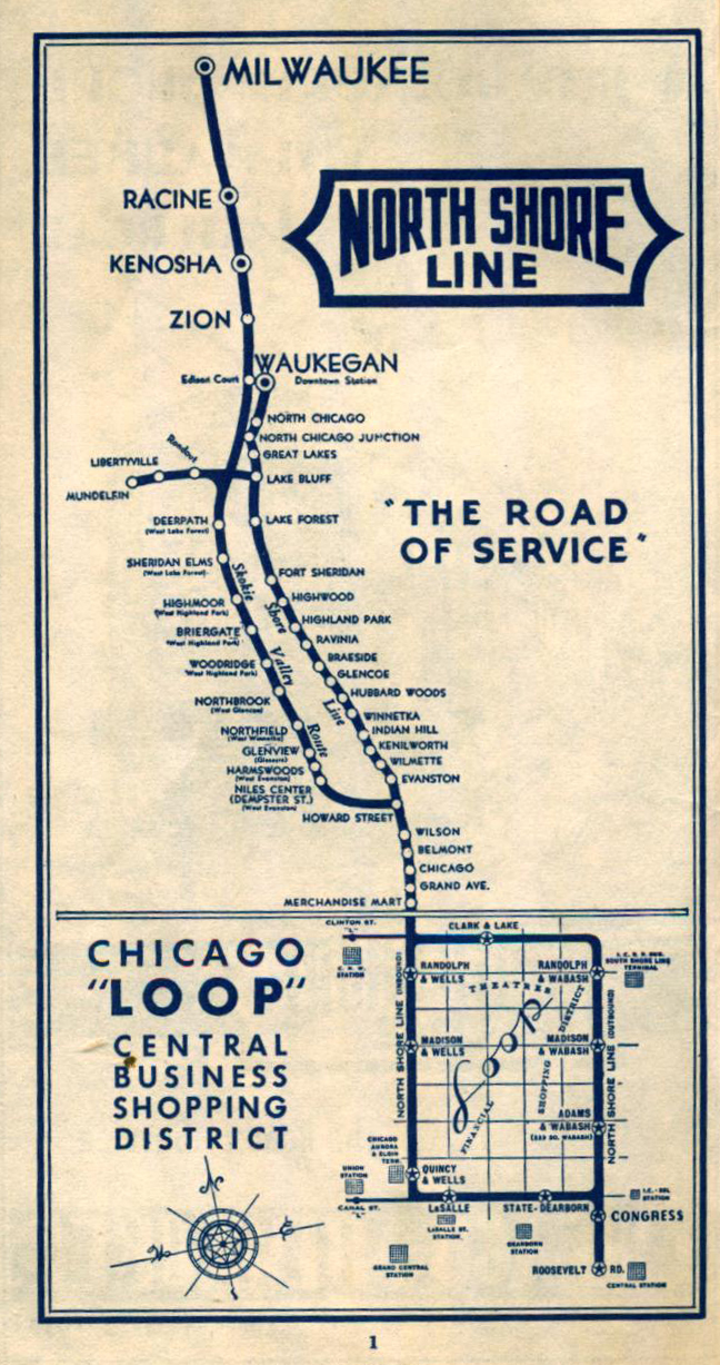
We rode the former North Shore Line car 715. This car used to run between Chicago and several cities along the North Shore, including Evanston and Willmette (where the Chicago Transit Authority’s Purple Line runs now), Skokie (where the CTA’s Yellow Line runs), and further north to Milwaukee. Check out the North Shore Line’s route map on the Northwestern University Transportation Library’s website.
You would have also seen car 715 running around the Chicago elevated loop, and making stops at the existing Belmont and Wilson elevated stations (although both of those have been replaced and tracks re-aligned for slightly faster service).
Once you’re done enjoying the historic trains at the FRTM, get back on the Metra and go home. Check out Elgin’s riverfront if you have to wait, and there are restaurants in downtown Elgin.
I bought a copy of The “L”: The Development of Chicago’s Rapid Transit System, 1888-1932, written by Bruce Moffat, a historian of electric trains in Chicago. Moffat currently works for the Chicago Transit Authority. (If there wasn’t a pandemic, you’d be able to request a hold on one of the 50 copies at the Chicago Public Library.)
The book is about the elevated trains that were built in Chicago, in competition with the street omnibuses (horse drawn), railways (cable cars and streetcars), and suburban trains (okay, some competition), prior to establishing the Chicago Transit Authority. The CTA is a State of Illinois authority, created by the legislature, that today owns and operates all of the historic and since-built elevated, subway, and at-grade ‘L’ transit as well as buses. It acquired all of the assets of all of the ‘L’, streetcar, and bus companies that were operating when it was established in 1945.
On with the story!
Back in December 1888, the Chicago City Council approved a franchise for the Lake Street Elevated Company to build a Meigs Elevated Railway above Lake Street from Canal Street to 40th Avenue (later named Crawford and now Pulaski Road), then the western border of Chicago. A tract of land west of 40th Avenue (Pulaski Road) was incorporated into the City of Chicago four months later on April 29, 1889.
If you go to the intersection of Canal and Lake Streets today you’ll see the Union Pacific railroad tracks above, heading into and out of Ogilvie Transportation Center, a skyscraper at 444 W Lake Street, a cigar store, and a vintage loft office building.
The Meigs Elevated Railway was a steam-powered elevated monorail – meaning each track had one rail to support a train.
You may not know this: I love monorails. When my family visited Walt Disney World my favorite ride was the inter-park and world famous monorail. I’ve also ridden the monorails in Disneyland (but I don’t remember my time there), Las Vegas, Seattle, Düsseldorf airport, Wuppertal, and three in Tokyo, Japan (Chiba City, Shonan, and Haneda airport; I missed the one in Tama).
I used to be obsessed with monorails. I became a member of The Monorail Society when I was a teenager and my first eBay purchase was a Disney monorail motorized toy in March 2000. I was jealous of my friends in elementary school who had a Lego monorail, and now they regularly sell for $200. I also built a SAFEGE-style monorail out of K’NEX in high school.
A drawing of the Meigs Elevated Railway monorail, originally published in Scientific American, July 10, 1886. Via Wikipedia; also printed in Moffat’s book where it is sourced from Railway Age, a trade journal founded in 1856 that still exists today.
It was invented by Josiah V. Meigs in Cambridge, Massachusetts; a 227-foot long demonstration line was built in 1886 on land that is now a Fairfield Inn hotel and before that was the Genoa Packing Co. (demolished in 2013).
The Lake Street Elevated Company organizers (seven incorporators are listed in the book) hired Morris H. Alberger to be the president. According to Moffat’s book, “Alberger had convinced his fellow directors that their railroad should use an experimental and relatively complex elevated railway system developed by Joe V. Meigs”. Alberger was also the president of the Meigs Elevated Railway Company.
Moffat discusses an eighth company organizer: Michael Cassius McDonald, “politically well connected and influential”. He was the “chief sponsor” and “promoter” of the Lake Street elevated proposal which came to be known as “Mike’s Upstairs Railroad”.
The Meigs Electric Railway – the monorail – was never built. Moffat says that the reason the monorail was never built was because it was difficult to promote and raised funds by selling shares.
Almost a year after City Council approved the MER to run over Lake Street, they “deleted the Meigs requirement” in November 1890 so that the Lake Street Elevated Company could build a traditional iron structure. The trains would also be “traditional”. (The first elevated train started running in Manhattan and the Bronx on August 26, 1878 – that was the Third Avenue Elevated – ten years prior to the Meigs monorail being approved in Chicago.)
Even before City Council “deleted” the franchise’s requirement to build a monorail, the Lake Street Elevated Company had already started building the iron structure for a train in December 1889, at Lake and Clinton Streets, where the Clinton Green Line station is now.
That’s the end of the story for the monorail, but I’ll continue talking about the Lake Street ‘L’.
The Lake Street Elevated opens!
Construction had reached “just west of Ashland Avenue” by October 1892, less than three years after the first iron girder was erected at Clinton. A year after that last construction milestone at Ashland, the tracks for service were completed to California Avenue (2800 West).
The Lake Street Elevated Company’s first service was set to begin on October 30, 1893. The opening was delayed, however, until an inauguration on Saturday, November 4, 1893, to mourn the death of Mayor Carter Harrison, who was assassinated during his fifth term. Passenger service began two days later on Monday, November 6, 1893.
Map of the Lake Street Elevated, from Market Street (now Wacker Drive) to Harlem Avenue and South Boulevard.
Heading closer to downtown Chicago
In early 1893, the Lake Street Elevated Company wanted to run their trains down Market Street (now Wacker Drive) from Lake Street to Madison Street.
Photograph showing the elevated stub track on Market Street. The view is looking east along Lake Street at Market Street, where the elevated train would turn south. Photo taken by a Chicago Daily News, Inc., photographer in 1908. The caption in the Explore Chicago Collections database says,
The Market Street “stub” ran past the future site of the Civic Opera Building, opened in November 1929. Operagoers and workers in the office tower of the building would have ridden the ‘L’ here until the Chicago Transit Authority
The Lake Street Elevated’s Market Street stub terminated at Madison Street. The Civic Opera Building is on the left. Image is from the CTA’s collection. Market Street was renamed Wacker Drive when the street was reconstructed as a double decker street starting in 1948.
Extending further into the Garfield Park neighborhood
Tracks were built six blocks west of California Avenue, to Homan Avenue, but the stations were incomplete. Service to the Homan station started November 24, 1893, and four blocks further west to Hamlin Avenue in January 1894.
The Homan Avenue station no longer exists. Today’s Green Line over Lake Street was rebuilt from 1994 to 1996 and the Homan station was abandoned. According to Chicago “L”.org, the CTA decided to move the station two blocks west to Central Park Drive (3600 West). It was “completely deconstructed in spring of 2000 and put into storage”. It was renovated, made accessible, and opened as the Conservatory-Central Park Drive station in June 2001.
Chicago “L”.org notes that this visitors access to the Garfield Park Conservatory, evens out stop spacing, but does not intersect a bus route which Homan Ave does. The CTA closed Hamlin station on March 18, 1956. I don’t know when it was demolished.
Onward, to Austin and Oak Park!
Back to the Lake Street elevated timeline. Serviced operated to Hamlin Avenue in 1894. The next year it was operating to 52nd Avenue (now Laramie Avenue), the western boundary of Chicago. On the other side of that boundary was the Township of Cicero. Austin, a township neighborhood, was annexed by Chicago in 1899. The Village of Oak Park eventually emerged from the township, incorporating in 1902.
Austin was location of Cicero’s town hall. The town hall building, at the Central and Lake station, is now part of the Austin Town Hall Park and Cultural Center, owned and operated by the Chicago Park District.
Austin Town Hall, the former town hall of the Township of Cicero. Photo taken in 2019 by Eric Allix Rogers.
Moffat’s book describes a lot of political controversy about extending the Lake Street Elevated into Cicero, which seems fitting for the Chicago region. Passenger service to Austin Avenue (now Boulevard) started April 19, 1899.
The next month, on May 14, 1889, trains that ran east-west above Lake Street came down a ramp – to the surface – onto north-south Lombard Avenue a couple of blocks south to Randolph Street. They turned west onto Randolph Street and continued until Wisconsin Avenue/Marion Street. The tracks on Randolph Street were in the middle of the street, and owned by Suburban Railroad, an interurban railway company.
The tracks were previously owned by Chicago, Harlem & Batavia Railway. I’m including that information because I grew up there. However, the railroad never made it that far: “No effort was made to extend the railroad to that distance place, but money was spent to purchase new locomotives and passenger cars and make other improvements.”
Residents here had the option of taking trains into downtown Chicago on the Chicago & Northwestern Railway. Those tracks are now owned by Union Pacific, which also operates the former C&NW lines as Metra’s UP-West Line. The line terminates at Ogilvie Transportation Center, which used to be called Northwestern Station, which was C&NW’s second location for their downtown terminal.
Moffat discussed these passengers’ choices, writing, “Although a ride on the nearby Chicago & Northwestern was faster, the “L’s” more frequent schedule, convenient Loop stops, and lower fare drew many riders away from the steam railroad”. The same is true today; the ‘L’ costs less than Metra but takes longer to reach the West Loop.
The story about the construction and operation of the Lake Street Elevated is almost done. I’m going to end it as soon as the train reaches the current terminus at Harlem Avenue in Oak Park.
Service to Marion Street started in late January 1901, on the street level of South Boulevard, thus ending service on Randolph Street a few blocks south. Trains started servicing the Harlem station on May 20, 1910. Remember that the reason the trains are now on South Boulevard is because Lake Street runs with a slight northwest diagonal, ends at the Chicago & Northwestern Railway embankment, and resumes a few blocks west. In 1961, the line was elevated onto C&NW’s embankment.
Even though the station is currently called “Harlem/Lake”, the station is at Harlem/South Boulevard, and Lake Street is one block north.
N.B.
Meigs’s railway was mentioned in an op-ed in the Boston Globe Magazine on Sunday, February 23, 1992, as the newspapers’s architecture critic, Robert Campbell, and Peter Vanderwarker, an architectural historian, lamented the towering car infrastructure proposed in the Central Artery/Tunnel Project (also known as “Big Dig”, the most expensive highway construction in the country), as well as the darkening effect of the elevated trains. It’s really quite an essay.
The op-ed in the Boston Globe Magazine, 2/23/1992
But competition was vicious. Arson and vandalism hampered Meigs, as did his insistence on old-fashioned steam power instead of electricity. Nothing besides the Cambridge test line was ever built. The Meigs monorail made its last run in 1894. Conventional elevated trains, modeled on those of Manhattan and far more massive than Meigs’, soon darkened Boston’s streets.
[snipped]
By the end of this decade, the view will have changed radically. A dramatic Babel of steel and concrete, perhaps resembling a great sports stadium, will rise like a gray mountain in the middle distance at the left of the photo. The introverted automobile will have won its long battle for supremacy over the sociable train.
“MEIGS ELEVATED RAILWAY – Changing TRACKS”, By Robert Campbell and Peter Vanderwarker
Meigs Field, a former airport in downtown Chicago that existed between 1948 and 2003, was named after Merrill C. Meigs, a pilot and former head of the Chicago Aero Commission. He believed that Chicago needed a third airport, within 10 minutes of downtown. The airport was built and named after Meigs in 1949. I haven’t found a relationship between the two Meigs.


