The ADU pilot program the City Council passed in December 2020 and took effect on May 1, 2021, will finally convert to a permanent law on April 1, 2026 – just shy of five years old. The new policy will increase the permanent eligibility area by a little more than double what the pilot areas allowed (a 135 percent expansion to be more precise). Further expansions are optional and up to each alderperson to decide when and where to “opt in” additional parts of their wards. Additionally, the construction of coach houses will have to comply with unusual labor requirements tacked on by an alderperson who called ADUs “an attack on the working class”.
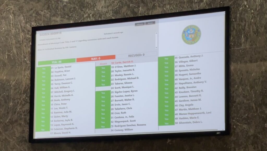
I was shocked when the ADU ordinance (read it here) passed unanimously, 46-0. The ordinance number is SO2024-0008918, and when you open the legislation details page look for the filename called “SO2024-0008918 ADU 9.23.25 (LRB 10a) (2) (1).pdf”
How do I feel? I’m relieved this seven-year-period of ADU advocacy is over, and I’m disappointed in the outcome. More advocacy will be needed to ensure that most alders maximize the eligibility areas in their wards.
Highlights of the new ADU ordinance
the ADU eligibility area increases from 12 percent of the city to 29 percent of the city, with options to increase further
the arbitrary cap of 700 s.f. of floor area allowed in each coach house has been removed (there is still a site-specific cap)
existing off-street parking can be removed in order to build a coach house on the ground level
B (business) and C (also business) zoning districts are now part of the eligibility area
ground floor space in mixed-use buildings in B and C zoning districts can be converted to ADUs without having to get a “special use”
The Chicago Fire owner, Joe Mansueto, plans to build a soccer stadium on “The 78”, a vacant property in the South Loop. The 78 is a planned development that was approved about six years ago to have office towers and about 10,000 homes in multiple buildings. Since the stadium will significantly alter the approved plan, Related Midwest, the owner of The 78, needs to present the revision to Chicago Plan Commission and gain their approval before also gaining approval from the City Council’s zoning committee and City Council.
Rendering of the stadium, looking north-northeast. Other renderings from the set show the area between the stadium and the riverwalk eventually being redeveloped into buildings and differently-designed outdoor spaces.
Here’s what’s changed
We can see what Mansueto and RM are proposing because they submitted their zoning change application to revise the PD back in July, which was subsequently posted in the City Clerk’s online legislation database. (A zoning change application and a Planned Development amendment are amendments to city law; refer to the approved plan in this PD 1434 document.)
The soccer stadium would be located approximately between 13th and 14th Streets. The rights of way for these two streets would be delineated and “dedicated” to the public.
Metra tracks would remain where they are. At the north edge of the site they enter the site about 185′ west of Clark Street, and then gradually shift to the east to hug Clark Street. The original plan would realign the tracks so that new streets could intersect Clark Street.
For the planners, the PD subareas’ boundaries are reconfigured.
Crescent Park is out of the plan. This central park would follow the historical Chicago River alignment, before it was straightened from Polk Street to 18th Street in 1926.
The riverwalk would be narrowed to 40′ from the currently approved plan for a 75′ wide riverwalk and 25′ “riverfront amenity zone” adjacent to buildings. (City law requires riverwalks to be a minimum of 30′ wide.)
Proposed open space plan
The stadium would have these pedestrian and bicycle access points:
Wells Street, south from Polk Street
Wentworth Avenue, north from 18th Street
A newly built LaSalle Street, south from the elevated Roosevelt Road. This is also where transit riders from the Roosevelt ‘L’ station or any of the buses that use Roosevelt or Clark would access the site.
There would not be access from Clark Street and points east; some of the Dearborn Park and Burnham Station residents may prefer this, given how some of them reacted when a new CTA Red Line station was proposed at the existing substation on the east side of Clark Street at 15th Street. RM eventually moved the proposal to be within The 78.
The proposed site plan also shows a publicly owned parking structure in phase one, below the Roosevelt Road elevation.
Site plan showing the stadium and a publicly owned parking structure
What’s next
Expect another 3rd Ward town hall, in September before the next Plan Commission meeting on September 18. The Plan Commission agenda hasn’t been set so it’s not confirmed that the development team will present on September 18.
The plan can also change again, between now and the Plan Commission meeting. What’s presented at Plan Commission will be what is presented to City Council.
The Chicago zoning code requires nearly every development, new or renovated, to provide on-site car parking. The code also provides relief from that requirement, most often in the form of cutting the requirement in half if the development is in a “transit served location”. Further relief – getting closer to zero parking spaces required – can be requested via administrative adjustment to the Chicago Zoning Administrator. (Learn about other methods of relief from Chicago’s parking mandates.)
Sometimes, however, that administrative adjustment must be converted to an application for variation that’s heard by the Zoning Board of Appeals (ZBA).
Pete Snyder and I tabulated all of the requests for parking relief – by way of a variation application – heard by the ZBA from January 2022 through January 2025.
Here’s what we found in that 37-month period:
There were 73 applications for parking relief (an average of two per ZBA meeting).
A little more than half of the applications (39) explicitly mentioned the development being in a transit-served location.
Those 73 applications requested relief from having to provide 661 car parking spaces.
At $10,000 per surface parking space that reflects a savings of about $6.6 million in construction costs.
Assuming all spaces would be on the ground, this is the equivalent of 3.5 acres of land which does not need to be acquired or if already acquired can be used for other purposes. Bell Park in Dunning is approximately 3.5 acres.
Each applicant pays $500 for the 72 variations and one applicant paid a $1,000 application fee for their special use.
Most applicants hired and paid an attorney to handle their application. Lawyer fees vary and are not made known to the public, but for variations are usually multiple thousands of dollars. Lawyers typically charge more for special use applications.
Google Maps aerial photo of Bell Park
Understanding how much relief from costly parking mandates is incomplete if we only study variations. The default method, at least for locations within transit-served areas, is to ask for an administrative adjustment, which has a lower bar of obtaining approval – but we don’t have data about the number of these. Another way to get parking relief is to apply for a rezoning and bundle the relief request within that application; data on that is forthcoming.
Follow the parking reform advocacy work in Chicago by visiting these websites:
I want to clear up confusion about how the inclusionary application process, included in the Connected Communities ordinance that took effect in June 20221, works to prevent new proposed projects from languishing in City Council.
It does not bypass alderperson prerogative, the custom of every alderperson supporting and going along with every other alderperson’s support or disapproval of a proposed project.
The inclusionary application process forces a vote for a proposed project that meets certain requirements. Sterling Bay is in the middle of this process, the first time the process has been activated, for their proposed project at 1840 N Marcey St, which would have 615 homes in place of a one-story office building.
How the process should work
An “inclusionary application” is a project that’s proposed to be approved as either a Planned Development or Type 12 and meets these requirements:
must meet these requirements:
it has a residential or mixed-residential use
the location is in an “inclusionary housing” area3
either that the full portion of ARO units is provided on-site (20 percent of all units) or that 20 percent or more of the units are affordable via some other agreement or code5
it has been approved by Plan Commission
a public meeting is held, in the ward of the proposed project, to explain the proposal and solicit comments
The Zoning Administrator and the Chicago Department of Housing Commission must concur that the proposed project meets those requirements6. Another requirement is that City Council’s zoning committee has not voted on it within 300 days of Plan Commission approval.
Chicago Plan Commission approved the 1840 N Marcey St proposed project on June 20, 2024. To stay in the approval process, zoning committee needs to not vote on the project before April 16, 2025 (300 days later).
However, and this is important, the zoning committee can take up the matter before that time and vote to approve or deny it. An approval would mean the project goes to City Council for approval or denial and concludes the inclusionary application process.
After that 300 day period elapses and the zoning committee has not voted on the proposed project, the applicant can submit written notification to the zoning committee chair to request that the committee act on the applicant’s inclusionary application. A clock starts. There are three outcomes at the end of 60 days:
zoning committee has voted and did not approve the proposed project
zoning committee has voted and approved the proposed project (a “do pass” recommendation)
zoning committee does not vote on the project and reports a “do pass” (approve) recommendation to City Council – this is the key part, the “shot clock”, of how the Connected Communities can ensure that a compliant residential project’s zoning change application doesn’t languish in City Council.
If it’s approved via #2 or #3, it proceeds to City Council which still vote on the project. And they can approve or disapprove it; there is no bypassing zoning committee or bypassing City Council.
Typically at City Council meetings, the Council votes on a motion that approves, in a single vote, all of the zoning change applications that the zoning committee approved (a.k.a. those proposed projects that have a “do pass” recommendation). If that happens, then the project has been approved by City Council.
But an alderperson could make a motion to vote on zoning change applications separately, and pull this proposed project out of the group. This is when alderperson prerogative might come out to play, and 26 or more alderpersons may go along with the alderperson of the ward where the project is located and who doesn’t support the proposed project, and the proposed project/zoning change application is killed.
It’s also when 26 or more alderpersons can make choices on behalf of the city and not on behalf of a discriminatory practice and vote to approve the project.
Notes
The inclusionary application process may have been added in part to avoid future lawsuits against the city when City Council allows a zoning change application to be deferred indefinitely (the languishing part of this article’s headline). Glenstar sued the City of Chicago after City Council let the proposed apartments at 8535 W Higgins Ave languish. ↩︎
A “type 1 zoning map amendment” changes the zoning district and obligates the property owner to build what meets the zoning district’s standards and what is described in their zoning change application. Contrast this with a “type 2 zoning map amendment” which allows anything to be built that meets the standards of the zoning district. ↩︎
An inclusionary area means a high-income area with a low amount of affordable housing and is considered, informally, not to be in a gentrifying process. See the ARO map on Chicago Cityscape. ↩︎
The proposed project is within 2,640 feet of a CTA or Metra rail station entrance or exit or within 1,320 feet of a CTA bus line corridor roadway segment listed in Table 17-17-0400-B. ↩︎
The code says, “20% or more of the on-site dwelling units are subject to recorded covenant, lien, regulatory agreement, deed restriction, or similar instrument approved by the Department of Housing”. ↩︎
See the full code starting at 17-13-0608 and going through 17-13-0608-B. ↩︎
The alternative headline is “Zoning assessment: how to propose a large building outside downtown Chicago when the current zoning code doesn’t typically allow that and the current zoning code goes against historical development norms for the city”.
I’ve said many times on social media how the Chicago zoning code doesn’t allow many extant buildings to be built because a zoning district that would allow the height, bulk, or density (“size”, for short) doesn’t exist anymore. All of those examples were outside of the downtown district because the downtown district still allows the size of all the extant buildings there.
The Old Town Canvas development would replace the Walgreens building. The development’s size is in line with all the other nearby high-rise residential buildings.
I am going to describe how a building with the size of the proposed Old Town Canvas development is allowed outside of downtown (view the boundary). The development shows how to use multiple standards in the Chicago zoning code to build a lot of needed housing and serves as another example of the Chicago zoning code being much more restrictive than its previous iterations.
I won’t belabor the point any further, but it shouldn’t take “zoning cleverness” to build more housing in Chicago.
About the development
The Old Town Canvas development’s size – proposing 500 homes in a building 395′ tall – is largely possible because of two longstanding standards in the Chicago zoning code, neither of which are unique to the site – there are no loopholes here.
Those standards are:
the “-5” zoning district’s allowance for nearly unlimited height if the property has a sufficient length of street frontage
the ability to establish a Planned Development and shift zoning capacity from one parcel to another, even across a roadway
1. Height limits in “-5” zoning districts
In a B-5 or C-5 zoning district, the height limit is based on how much street frontage1 the property has. For a property that has 100 feet or more of street frontage the height limit is normally 80 feet. However, an exception2 in the zoning code allows buildings to “exceed the maximum height” if approved and reviewed as a Planned Development3.
This means there is no maximum height, but there are certainly influencing factors: the support of the local alderperson, the support of the city planning staff, and guidelines from the FAA.
2. Planned Developments can move zoning capacity between parcels
A basic zoning assessment of the parcels for the building results in an estimate that 179 homes would be allowed here. This is much fewer homes than previous Chicago zoning codes allowed, and much fewer homes on a similar sized parcel than the four nearest high-rises which have about the same or more than the proposed number of 500.
To be able to build 321 additional homes the developer has proposed incorporating the unused zoning capacity of Piper’s Alley, a mixed-use development, and Moody Bible Church, where the most recent community meeting to discuss the traffic study was held this month.
I can’t get into specifics because I don’t have knowledge of how much unused FAR and MLA per unit that each of those other properties can transfer. To do that I would need to see architecture drawings showing how much floor area the buildings have already.
In this case, the owners of the other properties must give their consent to the Old Town Canvas developer to be incorporated into a new – or in this case, an amended – Planned Development and show this consent to the City of Chicago4.
That process is essentially the definition of what many people would call “air rights” (which I think more specifically means being able to build above something, like a railroad or roadway) and municipal governments would likely call “transfer of development rights”.
Neither “air rights” nor “transfer of development rights” are commonly used terms in Chicago. There are several buildings, however, that use air rights granted to them by the railroads that own the tracks under Riverside Plaza buildings.
In New York City, to explain an alternative implementation of TDR, development rights include the ability for owners of landmarked buildings and of buildings in special districts to transfer the zoning capacity beyond the geographic limitations of the Chicago Planned Development standards. For example, a landmarked theater in the Special Midtown District can be a “granting site” of development rights to a “receiving site” within the Theater Subdistrict.
Notes
In some other jurisdictions height limit is based on street width, and in Chicago’s first zoning code height was based on building depth and how much each upper section was set back from the street. ↩︎
There are codified standards regarding height in the Planned Development section of the Chicago zoning code, starting with the guideline, “High-rise buildings or towers should respect the context and scale of surrounding buildings with setbacks at appropriate heights which will also reduce the apparent mass from street level.” Other standards for high-rise buildings within Planned Developments are found in 17-8-0907-C. ↩︎
Section 17-8-0400 of the Chicago zoning code has a regulation affecting ownership and site control and how Planned Developments can have multiple owners controlling multiple sites. ↩︎